
For decades, research has shown that race is the single most important predictor of proximity to toxic sites, highways, incinerators, and other polluting industries in the United States. Age and language proficiency compound these inequities: children and the elderly are biologically more susceptible to pollution, while limited-English households face systemic barriers in navigating healthcare, zoning hearings, and permitting processes. Communities of color are more frequently exposed to multiple environmental hazards and simultaneous social stressors, including poverty, poor housing quality, discriminatory policies, and social inequality. The legacy of racist zoning and land-use planning policies have given rise to a hypersegregated “black butterfly” spatial distribution, whereby predominantly African-American communities occupy large swaths of disfavorable real estate accompanied by higher rates of poverty, crime, and food deserts compared to White neighborhoods.,
A nationwide study found strong associations between historically redlined neighborhoods and current day prevalence of cancer, asthma, poor mental health, and people lacking health insurance. Study researchers also found that residents in historically redlined areas of Atlanta, Cleveland, Miami, and the San Francisco-Oakland metropolitan areas were nearly twice as likely to suffer from adverse health outcomes, when compared to non-redlined areas. A nationwide study looking at 108 urban areas found that 94% of them had elevated land surface temperatures in formerly redlined areas relative to their non-redlined neighbors by up to 7°C. Digitized maps of redlined areas have recently become available and can be easily merged to historical census tract boundaries and demographic data. Supporting the idea that race is a potent indicator is the well-corroborated notion that even at the same income level, Black populations have higher exposure to hazards compared to their White counterparts., This is supported by many other well-cited studies by renowned EJ scholars (ex. Robert Bullard, Paul Mohai, Charles Lee), showing race has an independent effect on the distribution of environmental burdens, when isolating the effect of socioeconomic factors such as income.
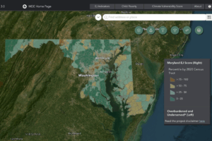
A 2020 study also showed that over 50% of people in 18 Maryland counties lived within 500 meters of a busy highway, many of which are frequented by diesel trucks idling, while the sound of backup generators can create noise pollution, and the smell of exhaust fills children’s lungs every morning. Maryland’s revised MDEnviroScreen represents a step backward in its ability to meaningfully assess and address these cumulative environmental harms. While the Maryland Department of the Environment (MDE) has made progress in releasing the updated tool and continues working with partners like CEEJH INC to refine its methodology, meaningful improvement requires confronting, not erasing, the social determinants of environmental injustice. For communities like Lothian, Maryland, Patuxent Riverkeeper Fred Tutman calls it a “sacrifice zone,” a term used for low-income or residents of color who live close to polluting industries or other hazards. Tutman contends that residents there have had a series of disruptive resource extraction and waste disposal facilities imposed on them over the decades, and little or nothing has been done to ensure those facilities comply with what little is required of them.

Communities’ fight for environmental justice in Maryland is visible in the drafting of the CHERISH Act, which stands for Cumulative Harms to Environmental Restoration for Improving Shared Health. It is proposed legislation in Maryland (HB 1484 / SB 978) aimed at embedding environmental justice protections into the state’s permitting and regulatory framework. Community-based organizations (CBOs) such as the South Baltimore Community Land Trust (SBCLT), academic institutions such as Johns Hopkins University, and non-profits like CEEJH INC were instrumental in meeting with legislators to draft language for the bill and testify during committee hearings. These groups have also met with MDE to emphasize that the indicators defining vulnerability must extend beyond traditional pollution measures to include residential segregation, historic redlining, and inequitable zoning and infrastructure siting patterns that shape exposure and access to environmental benefits. While the CHERISH Act did not pass during the 2025 Legislative Session, its skeleton insists that vulnerability factors must be integrated into screening and permitting; however, Maryland has downgraded them to “informational only.” This divergence is more than symbolic. It risks placing Maryland behind national momentum toward stronger, justice-centered standards. If CHERISH becomes law in 2026, Maryland must adopt frameworks that reflect the lived realities of frontline communities. By sidelining race and language, MDEnviroScreen risks being out of step with both science and policy.
A health equity-centered MDEnviroScreen is built on the principles of the Just Communities framework. The Just Communities program (Maryland Department of Housing and Community Development) is a relatively new state-level initiative (established under the Moore-Miller administration) that seeks to designate communities that were historically excluded or underinvested in, and then prioritize state funding to those places. The selection methodology for this mapper uses many indicators that are not race itself but are “race-proximal” or structurally indicative of exclusion or disinvestment, such as homeownership rates, residential and commercial vacancy trends, property value trends, indicators of redlining (historic), state imprisonment rates (proxy for criminal justice impacts), proximity to Superfund sites, exposure to lead-based paint, and asthma rates among older adults. For MDEnviroScreen, it means weighting indicators in ways that reflect cumulative harm, and it means centering community-generated data, from hyperlocal PurpleAir networks to resident-conducted surveys, in both scoring and decision-making. An effective state-level screening tool should also provide transparent scoring and mapping that communities can use in zoning hearings, permitting battles, and advocacy. It must be updated regularly with ground-truthed data from community science efforts and be paired with enforceable policy triggers: for example, requiring cumulative impact assessments before issuing new permits in overburdened census tracts.
Across the country, many environmental justice screening and mapping tools have recognized race as an essential indicator of cumulative burden. Michigan’s MiEJScreen continues to use race and ethnicity to identify frontline communities most affected by pollution, while Washington’s Environmental Health Disparities Map similarly integrates racial and demographic data to reveal long-standing inequities in exposure and health outcomes. Even the early version of the White House Climate and Economic Justice Screening Tool, designed to guide federal Justice40 investments, originally included race as a factor before being stripped of it after political pushback. The Luskin Center’s work on mapping tools offers useful guardrails for this redesign: make methodologies transparent; provide downloadable data; allow communities to review and validate inputs; and update models regularly with both agency and community-collected data. Good mapping is not just about prettier visuals. It is about producing defensible evidence that community organizers and public agencies can act upon. Maryland has made progress by releasing MDEnviroScreen and consulting with organizations like CEEJH INC, but the tool will only be useful if its metrics truly reflect who is harmed and why.
One actionable extension of the Governor’s Executive Order on Environmental Justice would be to track, publicly and continuously, the flow of state resources into communities of concern. If the EO is serious about its whole-of-government environmental justice approach, then agencies must account for not just where pollution occurs, but where public investments, grants, enforcement, mitigation funds, resilience dollars, and technical assistance are being sent. A simple per-capita tracking dashboard could show whether communities with the highest cumulative burden are receiving commensurate resources. That kind of fiscal mapping would convert mapping from diagnosis into remedy and would create an accountability mechanism for agencies charged with implementing equity commitments.
The same challenges in MDEnviroScreen emerged in our critique of the federal Climate and Economic Justice Screening Tool (CEJST), which, like MDEnviroScreen, removed race as a central metric under political pressure. Both cases illustrate a troubling pattern: federal and state agencies retreating from race-conscious analysis in the name of neutrality, even when data show that environmental burdens fall disproportionately on communities of color. Executive orders restricting race-based assessment risk hollowing out the purpose of EJSM—tools designed to correct historic wrongs cannot succeed if they deny the role race plays in creating them. Simply put, Maryland must map inequity. Excluding race, age, and language from the core of this tool erases the very metrics that define vulnerability in our state. Environmental justice is not race-neutral; the data have never been. Tools that fail to recognize this only perpetuate systemic inequities rather than dismantle them. Maryland has the opportunity to lead with integrity, by aligning MDEnviroScreen with the principles of the CHERISH Act and ensuring that the most burdened communities are finally seen, heard, and protected.